Understanding Maya Land Use at El Pilar
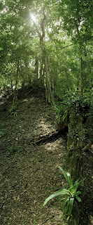
 This is not your typical Maya archaeological site. It doesn't wow you with its imposing monumental temples, plazas, ball courts and residential palaces like Palenque or Tikal. Yet it boasts 100 acres of plazas, pyramids and other structures, ranking it among the major ancient centers of the lowland Maya region. Straddling the border of Belize and Guatemala, the site of El Pilar, as this settlement has come to be known, doesn't flaunt its monumental prowess with cleanly exposed stone structures. Many of its ancient structures still lie protected by vegetation because it is the subject of a whole new paradigm of archaeological investigation -- a paradigm that may prove to be a model for many projects to come, and which may lead to solutions about how humanity can sustain itself and flourish by cooperating with nature instead of altering, subduing and destroying it. The research at El Pilar is based upon the premise that the ancient Maya worked WITH their tropical environment, as opposed to exploiting and transfiguring it, to create a flourishing civilization sustained by its natural environment or ecosystem. Exploring this concept could answer some age-old questions about what contributed to ancient Maya prosperity and, conversely, what may have contributed to its mysterious decline. By extension (and even more exciting), in this age of increasing global environmental awareness, El Pilar serves as a living museum and laboratory, drawing from what can be learned about ancient cultural practices to create a conservation model for the future of our own civilization.
How did the ancient Maya manage their landscape? Under the direction of Dr. Anabel Ford of the Mesoamerican Research Center at the University of California at Santa Barbara and the nonprofit organization, Exploring Solutions Past: The Maya Forest Alliance, the 2009 El Pilar field season will focus on testing a predictive model of ancient Maya land use through the lens of contemporary Maya forest gardeners. Understanding how these farmers use their land will help piece together the mosaic of land use in the past. Moreover, animals that survived the rise and fall of the Maya and are only threatened today by modern hunting practices must have formed a critical part of the Maya landscape, past and present. This season's work will integrate these diverse elements into one exciting field exploration. The core of the fieldwork will take place from May 1 to June 2009. Following is an outline of the many elements that will be studied during the season:
Activities:
- Floristic complexity of today: canopy levels
o In the fields and orchards: polyculture, agroforestry, forest regeneration
o Traditional land management: soil maintenance, land cover, pest management
- Food chain of the forest garden: faunal distribution
o Corn is the canopy: browsers, small mammals, reptiles, birds, insects
o Orchard/forest as canopy: all the above, arboreal fauna, top predators
- Mapping Maya house sites and soil at El Pilar
o Urban El Pilar: high density and complex distribution of structures
o Rural El Pilar: low density and simple distribution of structures
o Traditional farmer input: understanding the rural component
Photo credits: top photo, Macduff Everton; others, BRASS Archives
Labels: El Pilar, Landscape Archaeology, Maya Forest Gardeners


2 Comments:
This comment has been removed by the author.
The dissertation of the work made by Sébastien Merlet (Sebeto) on this predictive model and the resulting conclusions is available on the Internet: Maya predictive model and land use modeling at El Pilar
Post a Comment
<< Home